Gregory National Park - Jutpurra
Popular With Locals - Little Known By Tourists
Gregory National Park (now called Jutpurra National Park) is a spectacular 13,000 square kilometre wilderness area in Australia's Northern Territory, starting 200 km west of Katherine. It's mainly a park for outdoor and four wheel driving enthusiasts, but not only! On this page we'll look at how you can safely explore and enjoy this wilderness.
Update: In May 2010 the park was returned to its traditional Indigenous owners and renamed into Jutpurra National Park.
Getting there | What to See and Do | Victoria River Sector | Bullita Sector
© NT Tourist Commission
The Victoria Highway, which connects the Northern Territory with the west coast, leads through the eastern part of Gregory National Park.
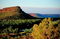
You can get a first glimpse of the dramatic escarpments as you drive through. If you come from the Northern Territory side that is... Most people do.
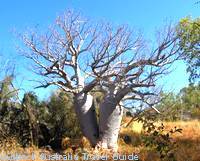
If you reach Gregory National Park coming from Darwin/Katherine you will notice a difference. The tropical habitats that make up most of Australia's "Top End" give way to semi-arid landscapes.
You will also for the first time see the unique boab trees, which can only be found here and across the Kimberley region.
Striking gorges, rugged sandstone and limestone terrain, big rivers with fascinating flora and fauna and signs of a rich Aboriginal and pastoral past beckon.
Many of the parks attractions require 4WD (four wheel drive) to access. Actually, the four wheel drive tracks are an attraction in itself. But there are also some walks and lookouts that you can enjoy without even leaving the highway.
Let's take a closer look at the remote wilderness that is the Northern Territory's second biggest national park.
How to get to Gregory National Park
From Katherine
Head west from Katherine on the Victoria Highway and you can't miss Gregory National Park. The highway cuts right through the Victoria River sector, the first of two separate sections of the park.
If you need maps, fact sheets or information call in at the Victoria River Roadhouse which is situated inside the park, just under 200 km west of Katherine. Collect free brochures about the park and have a look at the informative displays on the veranda. The people there can tell you about the current state of the roads and tracks within the park. (Important to check during and near the wet season!)
The roadhouse also offers a camp ground, motel rooms, meals, Victoria River boat tours and more. Don't forget to fill up your tank while you're there.
From Kununurra
If you are coming from the Kimberley you will first reach Timber Creek. Fill up your tank at the roadhouse and ask for directions to the Gregory National Park Visitor Center (Parks & Wildlife Commission) and ranger station. It's just around the corner. At the Visitor Centre you can find all the information and maps you need.
The access road to the western part of Gregory National Park turns off the Victoria Highway 10 km east of Timber Creek.
Seasonal access
All four wheel drive tracks will be closed during the wet season between November and March. Unsealed two wheel drive roads can become temporarily inaccessible and even the Victoria Highway gets closed at times, (when the Victoria River bridge is under water, it happens every wet season...)
What to see and do at Gregory National Park
How much you can see of Gregory National Park depends on your vehicle. Most of the park is only accessible by four wheel drive.
But since the Victoria Highway runs right through the middle of the smaller eastern part there are several walks and lookouts that anybody can get to. You don't even have to leave the highway.
Victoria River Sector (the small eastern part)
Escarpment Walk
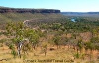
This walk starts right at the highway, only 2 km from the roadhouse.
The escarpment walk is a 3 km return rocky and steep track that takes you to the top of the ridge from where you have breathtaking views over the Victoria River and the escarpments.
Along the trail you find signs and displays that explain the Nungali and Wardaman people's dreamtime stories of the area.
The trails is not technically difficult but it is steep in parts and you should definitely take some water. Allow an hour or two, depending on how fit you are.
Joe Creek Picnic Area and Nawulbinbin Walk
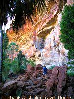
Don't miss this one! Look for the turn off to the picnic area 10 km west of the Victoria River Roadhouse. The 2 km access road is unsealed but ok for 2WD.
The drive in and the picnic area itself are already spectacular, but the walk leaves you speechless. The 1.7 km loop walk takes you up the slope to the base of the escarpment cliffs.
It follows that cliff and eventually turns down again and leads you back to the car park along the valley.
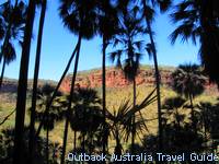
The whole slope is covered in Livistona palms and the higher you get the lusher the vegetation becomes.
Once you reach the cliffs you are walking in the shade of unexpectedly dense tropical vegetation. Ferns are nestled in cracks of the wall where water is still trickling down at the very end of the dry season.
From the deep cool shade you look out over the sun drenched valley to the dramatic escarpment cliffs on the other side.
Awesome.
The walk is moderately difficult. It's steep in parts, involves some climbing over big rocks and you need to be aware of loose rocks when negotiating the slopes. Take some water and take your time. It's not the kind of scenery that you will see every day...
Old Victoria River Crossing
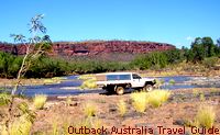
The crossing is not far from the roadhouse, you will see the sign.
This is where the old highway used to cross the river before the bridge was built. The access is strictly four wheel drive only, but it's not far, you could walk down to have a look.
It's a pretty spot and inviting to dip your feet in the water. But don't even think about swimming! The Victoria River is full of saltwater crocodiles.
Bullita Sector (the large western part)
Jasper Gorge
Jasper Gorge is not actually inside Gregory National Park but situated between the eastern and western part. It's a permanent waterhole and beautiful camping spot to spend a night. The access road is part of the Buchanan Highway to Top Springs. It is ok for two wheel drive but make sure you have at least one good spare tyre...
Bullita Homestead and Limestone Gorge
These are situated in the bigger western section of Gregory National Park. You find the Bullita Access Road 10 km east of Timber Creek. During the dry season it is possible to reach Bullita Homestead by 2WD, but you need a lot more clearance then a normal car has to get to Limestone Gorge. And I would definitely advise against towing a caravan...
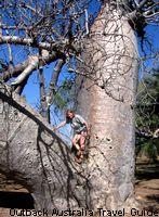
Bullita Homestead is 42 km from the highway and gives you good insights into the life of the early pioneers and pastoralists. It's a nice place to escape the heat of the day for a while and to do some time travel.
The homestead itself is in its original condition and the stock yards outside are lovingly maintained with local timbers, Lancewood and Bloodwood. The inside of the homestead tells the story of the first settlers. How the homestead was built, the hardships they faced and their chilling end...
The Bullita Campground is not far from the homestead, just follow the signs. It's on the banks of the East Baines River and you can go down to the river crossing and try to catch some dinner.
To get to the scenic Limestone Gorge take the turn off 34 km along the Bullita access road. Despite what some brochures say, you do need a four wheel drive to get to the campground at the end of the 8 km track.
The Calcite Flow Walk 2 km before the campground could possibly be reached in a 2WD, but take it easy and be prepared to turn around if the track gets too difficult. The Calcite Flow Walk is a short and easy walk and gives you good views over the limestone formations that this part of Gregory National Park is famous for.
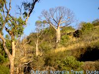
The 1.8 km Limestone Ridge Loop Walk starts at the campground. It winds along the ridge through the interesting limestone landscape, gives you good views over the East Baines River Valley and interesting explanations about the local flora.
All in all it's a wonderful, nicely hidden place to spend a night. If you can get to it...
4WD Tracks
Gregory National Park contains a network of four wheel drive tracks. These tracks really are for the four wheel driving enthusiast. You need to be well prepared and well equipped to tackle them, but if you are you will see some spectacular wilderness country. Basic camp sites are located along all of the tracks.
Bullita Stockroute (90 km/8 hrs): A loop track from the Bullita homestead leading back onto the Bullita access road.
Humbert Track (112 km/6 hrs): This alternative exit route takes you to the Buchanan Highway.
Wickham & Broadarrow Tracks: Both lead into the very remote southern regions of the park and eventually meet the Buntine Highway between Top Springs and Halls Creek. If you want to do the full round trip, down one track and back the other, allow three days.
Let me repeat that this are serious and challenging trips for experienced drivers. You need to be well informed, well prepared and totally self sufficient. You also need to register with the rangers and obtain a permit.
Travelling the Northern Territory?
 The free Outback Pocket Guide
is a great introduction to travel in the region.
The full Top End Travel Guide 
shows you how to make the most of your adventure in Australia's tropical north.
NEW! Destination Red Centre is the latest addition in this popular series. Monica Coleman takes you through Australia's red Outback heart, offering all the detail and insider tips that you have come to know and love about our guides. With special emphasis on Aboriginal communities and culture.
A must have if you travel to or from Alice Springs/Uluru.
For more information, permits etc. contact the Parks & Wildlife Commission of the Northern Territory:
Gregory National Park - Timber Creek
Ph: 08 8975 0888
Fax: 08 8975 0779
Bullita
Ph: 08 8975 0833
Fax: 08 8975 0838
Read about other National Parks in Australia
Australian National Parks Site Map
Return from Gregory National Park to Outback Australia Travel Guide home page

